Puke Ariki - Dry Creek to Korokoro (Belmont, Lower Hutt)
- Mr and Mrs Walking with Kids

- Nov 15, 2025
- 4 min read
Updated: Feb 22
Saturday 15th November 2025
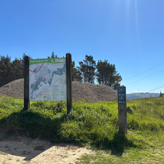
Location: Hebden Crescent, Kelson, Lower Hutt 5010 (There's a camping ground at Dry Creek with toilets and drinking water.)
Difficult | 6-8hours | 24km | Dogs not Allowed | Not Buggy Friendly
Despite being within sight of town for much of the route, this track feels long and surprisingly isolated, so it pays to be well-prepared. When planning your walk, be sure to check wind speed and direction—like the Skyline Walkway, the Dress Circle Track can be tough if you’re walking into a strong breeze. Most of the trail is quite exposed, so dress appropriately for the weather.
A heads-up for families and curious walkers: the farm in Belmont Regional Park is operational and closes during calving, so make sure it’s open before you set out.
Noting that the Wellington wind was gusting from the north, we opted to walk the track from north to south. We’d been advised to tackle it this way—getting the steep climb up Boulder Hill out of the way first—though we still found ourselves “towing” Ms 10 up the final stretch of the hill!
We parked the car at the Korokoro Dam entrance and Uber’d up to Dry Creek. You could catch a train from Petone Station to Manor Park Station if you don’t mind adding an extra kilometre or two at each end. We had planned to do just that… but the trains weren’t running. Cue the bus replacements, delays, and general “joy vacuum” that nobody wants on a weekend walk!


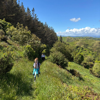
It was a bright, sunny late-spring day, so we lathered up with sunscreen at Dry Creek and made sure everyone hit the facilities before setting off. The first 100 m of the track winds through bush, but most of the Boulder Hill ascent follows a wide, pilon service road with a steady gradient. Plenty of stops were needed to peel off layers and grab drinks—though it was a little alarming just how much water we were going through! Still, it’s the bulk of the climb for the day.
About two-thirds of the way up, the service road turns into a farm track: still wide, but noticeably steeper. We reached the top in under an hour and rewarded ourselves with a well-deserved snack while taking in the view.


Past the boulders, we followed the trail of signs and bright orange markers down through the farm, making our way toward the access road. Along the way, we had some unexpected company: curious cattle. They clearly wanted to say hello—much to Mum’s delight and the kids’ wary suspicion! It was a gentle reminder that in the countryside, every hike comes with its own set of friendly (and very inquisitive) locals.
Don’t lose sight of the orange markers: the kids suspected a few had been used as “butt-rubbing posts” and were now lying sideways on the ground.


Down, down, down the path we careened—like caffeinated squirrels—until it spat us out onto the farm road. The Puke Ariki Track signs waved at us like old friends (or slightly judgmental relatives) and lured us deeper into the farm, past the old ammunition bunkers that look suspiciously like giant concrete picnic tables, and toward the abandoned airfield. On a clear day, the views are jaw-dropping with plenty of spots to pause, catch your breath, and pretend you’re in a dramatic movie montage. Windy? No problem! The bunkers double as perfect storm shelters.


The path up to the Dress Circle Track winds along cheerful little orange triangles—but of course, we decided to freestyle. After an epic trudge through paddocks full of springy, judgmental lambs and a heroic rescue courtesy of AllTrails, we finally found our bearings. Lesson learned: those triangles know the way way better than your overconfident sense of direction ever will. Honestly, follow the triangles—they’re basically tiny orange life coaches.


The Dress Circle Track winds its way south along a farm track toward the Trig, offering breathtaking views of both the Hutt Valley and Porirua. The path undulates with a few sneaky steep spots, but honestly—it was far and away the highlight of our day. Every twist of the track felt like a mini adventure, and the scenery was breathtaking. You feel like you’re on top of the world. We even found a rock troll!


Eventually, we made it to Belmont Trig, but the wind was gusting like it had a personal vendetta, so we didn’t hang around. Down, down, down we went to Baked Bean Bend, finally finding a perfect spot to grab a snack, catch our breath, and laugh about all the “adventures” we’d survived before the last push home.


After a big day of hiking, the walk from Baked Bean Bend to Cornish Street felt deceptively long. But sore legs didn’t stand a chance against the promise of ice cream. After an hour of relatively flat strolling, we made it back to the car. The sweet relief of kicking off our boots was only rivaled by the…ahem…distinctive aroma in the car—but with gelato on the horizon, nobody was in the mood to complain!


Age of Kids: 10yr and 13yrs
Walking Time: 7hrs
Distance: 23km, would be about 25km if we had used the trains between Petone and Manor Park.
Buggy Friendly: Not.
Difficulty: This was by far the hardest day walk we’ve ever done. Back home, feet up and a wine for mum, beer for dad… and somehow Mr 13 had enough energy left to dash off and play basketball with his friends. Clearly, exhaustion is optional when you’re 13.
Wet Feet: No.
Amenities: There's a toilet and drinking fountain at the carpark at dry creek. There is little else along the way.
Dogs: No, the working farm means dogs can’t come on this one.
Cellphone Reception: The cell reception was patchy
Things to be aware of: This is a long walk! It’s a lot of fun, but it’s definitely a bit of a slog. Town might look close, but finishing early is trickier than it seems—so plan accordingly. Make sure everyone has plenty of water, snacks, and the right clothes for the weather. Trust us: you’ll thank yourself on the windy stretches! (Not for the faint hearted or unpracticed walking legs).


Comments